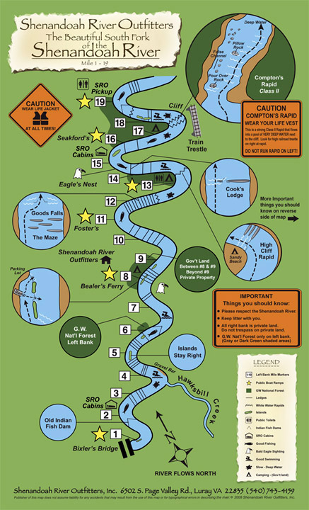
Here are the Boat landings we use for your river trips:
# 1 Low Water Bridge Inskeep Boat Landing (VA Game) # 8 Bealer’s Ferry Boat Landing (G.W. National Forest) # 11 Foster’s Boat Landing (VA Game) # 13 Good’s Falls Boat Landing (G.W. National Forest) # 16 Seakford’s Boat Landing (G.W. National Forest) # 17.5 Compton’s Rapid (right bank private) (left bank G.W. National Forest) # 19 SRO’s Pickup* (End of day trips or two day trips) #20 SRO’s alternate Boat Landing (end of 1 day trips) # 28 Bentonville Boat Landing (end of some 2 day trips) #45 Front Royal Boat Landing (end of 3 day trips)
For groups of 3 or more canoes, we can offer trips up to 100 miles. Just call us to help you plan that extended trip.
Shenandoah River Outfitters Inc & publishers of these maps do not assume liability for any accidents that may result from the use of this map or for typographical errors in describing the river
Please respect the Shenandoah River. Keep litter with you.
Do NOT trespass on private land. All right bank(East) is private land. G.W. National Forest is only on left bank (shaded dark green areas of map)
RIVER TRIPS
10 RIVER CABINS & Camp OutBack
RATES & RESERVATIONS
CONTACT US
540-743-4159 6502 S Page Valley Rd Luray VA 22835
Open 8 AM to 5PM Saturday in Summer, Sundays 8:30 AM to 5 PM, Midweek 9 AM to 5 PM